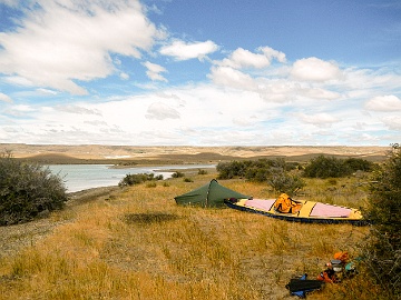
Waterwalker is the title of Bill Mason's iconic movie on canoeing. And indeed, canoeing and walking have a lot in common. Not only the same traveling speed of about 4 kilometers per hour, but also the meditative rhythm. Countless steps on a hike match numerous paddle strokes on rivers and lakes. Difficult rapids where every paddle stroke needs to be placed just right correspond to rugged mountain stages, where every single step should also be well placed. And both keep the number of people you will encounter down: the portages that get you around difficult river sections, and the steep mountain ridges where the going gets tough. And the lessons are the same, whether in high mountains or on remote rivers. Lessons about one's own insignificance in the face of an overwhelming immensity. Modesty and humility will get you further.
But there are also marked differences. While you can wander around in Central Europe with, let's say, 10 kilograms of equipment (all told), a canoe trip in Canada's Back of Beyond may require an outfit that soon weighs 10 times as much (excluding food). Take the focus during preparations: before a canoe trip one invests a lot of time to ensure that nothing is left at home (checklists), while prior to a hike one strives to leave as much as possible at home in order to cut down on weight. Take drinking water: In Canada, it carries your canoe. On a hike you carry the water. Or the margin for error: While a single wrong step on a hike can sprain your ankle and derail your journey, it is unlikely that one wrong paddle stroke will bring your journey to a screeching halt. Take the consequences of a blunder, or bad luck: Where in Central Europe a rescue helicopter is often not too far away, a distress signal triggered in the far north of Canada can activate a Hercules CC-130 many thousands of kilometers away. Or take free miles: Where you may well travel long distances on a river without exerting yourself, you won't cover a single meter on a hike if you don't push yourself. Take silence and solitude, so closely associated with Canada's North. Even in ancient forests or on high mountain slopes in Central Europe, silence and solitude are a matter of good fortune. While solitude in the Canadian North can be measured in weeks, in central Europe it is more a matter of hours - or, if you are lucky, a day or two. Whereas many mountains in Canada north of 60 are still nameless, in Central Europe every knoll has a name. Simply put: Northern Canada is ideal for extended escapes, while the mountains of Central Europe are limited to more modest ones — micro escapes.
These galleries are intended to convey an idea of what is in store along the way. They are meant for those who are planning to go, and for those who share an interest in long distance hiking and mountains but cannot go and see for themselves. Munich to Venice entices with three different countries, each with its own food, customs and language. The special charm of the Pyrenees, for me, was crossing Spain from one sea to the other. The Grande Traversata delle Alpi (GTA) amounts to a physical challenge accompanied by Italian food. The Dientes are hardly worth mentioning from a hiking perspective. It takes only a few days to complete the circuit. But this trail is truly south of 60 degrees (north) and the southern beeches are a beauty in their own right. The Via Dinarica came out of the need to start early, in June, on a route with mountains but without trouble from snow. In terms of unbroken natural beauty, I would not rank the Via Dinarica first. This hike is for those who are particularly interested in the Balkans. And it is a good idea to learn about the complicated and tragic history of this region beforehand. There is a very good 3-part documentary: "Balkan in Flammen" (in German), on Youtube and in the ZDF Mediathek. The English version runs under the title "The Balkans in Flames" – worth a search, as its availability keeps changing. Revisiting the Pyrenees was due to the pandemic. And with travel restrictions changing every fortnight in 2021, a jaunt into the Alps seemed the most promising and straightforward.
This site is also an argument for carrying your own tent. Some campsites and the hours you spend there cannot be matched by anything you could ever get in a (serviced) mountain hut.
In terms of numbers the routes work out as follows, the most demanding first. Ascent is cumulative – since these routes begin and end at low altitude, the descent adds up to roughly the same.
| Route | Distance | Days | km / day | Ascent | Ascent / 100 km |
|---|
| Grande Traversata delle Alpi | 700 km | 50 | 14.0 | 46 km | 6700 m |
| GR 10 (French Pyrenees) | 911 km | 67 | 13.6 | 51 km | 5600 m |
| Vienna to Lago di Como | 1078 km | 73 | 14.8 | 57 km | 5300 m |
| HRP (Haute Randonnée Pyrénéenne) | 740 km | 58 | 12.8 | 37 km | 5000 m |
| Munich to Venice | 610 km | 33 | 18.5 | 30 km | 4900 m |
| GR 11 (Ruta Transpirenaica) | 800 km | 50 | 16.0 | 34 km | 4300 m |
| Via Dinarica | 1130 km | 74 | 15.3 | 42 km | 3800 m |
Now, these ascent figures should be taken with caution. Different algorithms produce different results from one and the same GPX file: Outdooractive, for instance, puts the HRP at 43 km of ascent, Google at only 37 km.
Google's 5 MB limit for GPX tracks makes matters worse, because a larger file has to be thinned out first – and fewer track points mean less ascent. The hike from Vienna into the Alps is a good example. At 8.7 MB and 55,787 positions, Routeconverter calculated about 82 km. After compacting the file to 4.3 MB, roughly half the positions, the same tool gave 77 km. Google's own algorithm, applied to that track, arrived at 57.6 km.
In absolute terms the numbers are therefore not worth much. For comparing one route with another they are – as long as the same algorithm was used throughout. On that basis it is fairly safe to say that the GR10 is the most demanding way to cross the Pyrenees from one end to the other.
And none of this is rocket science. Most of the tracks were downloaded from the web beforehand and trimmed where Google needed them smaller, and I certainly strayed from them here and there. The GR10 is the exception: I pieced that route together on my desktop the way I intended to walk it, then corrected it from memory afterwards. So take the figures for what they are – a rough idea, not a measurement.
All routes on one map can be found here.
When asked which trail in the Pyrenees is the best, I gave it some thought and came to this conclusion: Start from the Atlantic, because the vegetation and the weather are similar to what you get in a German summer. You slowly make your way to the drier and warmer Mediterranean. Choose the GR11 for the Basque Country, because I believe it is drier there than further north. Take the GR11 to Ibón de Estanés. Around here change over to the HRP – if you are going to walk the Haute Pyrénées, walk the haute part on the HRP. Around Refuge du Portillon I would suggest switching over to the GR10, to Refuge d'Espingo, to make sure you walk the Ariège. The Ariège (kind of starting past Bagnères-de-Luchon, around Fos and Melles) is special, and to me the highlight of the GR10, not to be missed. From Mérens-les-Vals on I would choose the HRP again until Refugio Ulldeter, where I would switch back to the GR11 in order to walk through the Garrotxa (txa pronounced like the “cha” in Cha Cha Cha). Albeit significantly shorter than the Ariège, the Garrotxa is just as unique. And, you are on track to finish at Cap de Creus, the definitive final landmark of the Pyrenees on the Mediterranean side. Of course, choosing one way over the other you will miss out on something else. But if you want to combine “the best” parts, the above is not a bad choice. If you are interested in walking any of the three trails in full, I would suggest the HRP – provided you have enough experience in the mountains. If not enough yet, start with the GR11. Of the GR10 I would only recommend the Ariège. – my two cents’ worth.
.jpg)